|
What We Observed and Learned Our objective over the last week was to standardize a methodology for the mapping analysis of one transit system in one county: SamTrans in San Mateo County. We were able to use GIS to isolate the Communities of Concern (CoC) within the 3-mile buffer of the Caltrain, defined as having access in the context of our project. We observed hotspots in the incidence of CoC with access to Caltrain located near San Jose (in the south bay), around East Palo Alto, and Eastern San Francisco. It is also of note that multiple communities in Gilroy and Morgan Hill appeared in our analysis -- their geographic isolation could factor into a future analysis. However because they fall outside of the service area of Samtrans, Muni, and VTA, we are unlikely to engage with them during this initial pass. 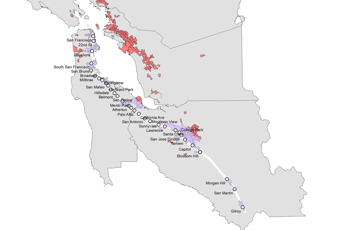 map of Caltrain stations [white], communities of concern [red], within 3 miles of a Caltrain station AND within a community of concern [purple] We’ve also identified that many of the topics from readings and lectures are extremely relevant to our work with Friends of Caltrain and Seamless Bay Area. In Dr. Tien’s lecture, we discussed the ethical concerns surrounding some types of research and the beneficiaries of official research. Along these lines, we also analyzed some case studies which seemed to operate under good will but actually had some aspects that were morally questionable under the guise of research. This lens carries over into our work with the Caltrain scheduling. More specifically, we are reminded of the Moving Silicon Valley Forwards reading from Week 1, which highlight relevant questions about ridership, showing that “the VTA bus system has nearly 75 percent of its ridership from communities of color but receives only $8.16 of public subsidy per passenger. In contrast, Caltrain has only 40 percent riders of color and receives nearly twice the subsidies ($15.49 per passenger trip)” (9). Coupled with some initial mapping that shows that the majority of CoC’s are clustered in the East Bay where Caltrain doesn’t reach, this project doesn’t seem to allocate research about public transit ridership in the right places in the Bay Area. However, we also recognize that one of our community partners, Friends of Caltrain, focuses just on Caltrain and the surrounding public transit options, but this question of where our research efforts are going is worth exploring in further detail as we progress with this project.
With regard to research ethics, we also acknowledge that we are undertaking in a kind of analysis that does not engage directly with the people we are studying. However, the recommendations that result from our analysis will likely need to be substantiated through field research down-the-line. Those researchers must be accountable to the current and future transit riders they will work with, guiding their research as well by the desires of those subjects; our final report will reiterate this. Last week Adina had mentioned that SamTrans and Caltrain issued a response to the Grand Jury report about the action they are going to take toward synchronization of transit schedules. We received these documents from Adina and read them to get a better idea about what these plans look like. Our current understanding of the project is as follows: once we create the new GIS layers of CoC with access to Caltrain, we need to see how these areas overlap with factors that impact access (e.g. protected bike lanes, street lights, disability access, etc). Based on our phone call on Friday with Adina and Ian, we have a good understanding of what types of recommendations we should be making. By looking at this overlap, we will be able to understand where barriers to Caltrain access are most prevalent and what geographies the recommendations are for. Update on Project Activities Following our meeting with Adina and Ian last week, we received more information about which areas to pursue with analysis on arcGIS. In this discussion, Adina narrowed down the scale of our project. Since then, we’ve compiled a series of layers on GIS that would align with Adina’s goals: neighborhoods, parks, cities, counties, SamTrans stops located in communities of concern, and all Caltrain stations. We have also brought in other layers that we hope will help us draw out potential barriers to Caltrain access: availability and quality of bike routes, street lighting, and altitude changes. Ian referenced “isochrone” mapping (how far can someone get in x minutes via a certain mode of transport), and we have found tools that will help us use this technique to assess access in other terms than simple Euclidean distance. Finding data layers is harder than anticipated, because transit operators/city governments/advocacy organizations between the three counties we are working in differ greatly in the format, quantity, and quality of data they provide. Nevertheless, we can start our analysis with partial data (we do not need to know about streetlights to analyze bikeability). A majority of this week’s time was spent installing ArcGIS on each team members’ computers and beginning to familiarize ourselves with how to use it. This step, which should have been relatively simple, resulted in lots of frustration - we’ve run into license authentication errors and had trouble installing Windows on MacBooks (Windows is the only supported operating system for ArcGIS), among other small logistical conflicts. We hope to make up time this week after re-orienting ourselves with the project through a call with our community partners, Ian and Adina. We have also been working on our Project Scope of Work, which will primarily draw upon the first timeline we included in Reflection #1 and the project outline provided by the course. We hope to finish the first draft by Monday so we can ask our community partners for feedback before the deadline. Challenges As with any collaborative project, scheduling has been a challenge for our team meetings. With our busy schedules, there are few times when we are all available to meet, which has resulted in some members missing the meetings altogether. Of course, we keep each other up to date on any project developments and important information from our community partners, but it would be best if all members could be present to add to the discussions. For this week, in particular, there was also the occurrence of a religious holiday, which meant one member was unavailable to work on the project that day. This was not detrimental, but with limited time for the project, timeliness is key. Another challenge we have been facing is that we are still unclear about the types of recommendations we should be making with regards to transportation, infrastructure, and other related subjects. Although we have begun to narrow down the GIS layers we should be compiling, we still have to think about which direction we want to follow when we analyze the data. There are many factors involved in transportation access and in determining communities of concern, so we need to further narrow down our scope of work to ensure our project is manageable. This also brings up the question of whether or not we are doing some type of scheduling analysis with SamTrans, Caltrain, and the other transportation networks. An in-depth analysis of how these schedules line up or don’t line up with the needs of the Communities of Concern would be very time consuming and push beyond the scope of the project’s purpose, but some scheduling analysis could be beneficial for informing our recommendations. There is also the problem with making assumptions about the factors involved in our analyses. For example, what can we safely assume about the population data without creating a false image of the communities of concern? What can we safely extrapolate or deduce from the data that is representative of the communities we are examining? One interesting observation we also made in the past week was that there seemed to be a significant number of communities of concern in the East Bay between Richmond and Hayward - areas served more directly by BART than by Caltrain. This would be interesting to investigate as time permits, but it may be work for future groups since our project is mainly focused on Caltrain and the local bus systems working around it. Comments are closed.
|
Archives
November 2020
Categories
All
|
 RSS Feed
